

The King County Water and Land Resources Division recently updated its list of river hazards in King County. Included on this list of updates were three locations of the Green River.
-
- Green River closed west of Highway 18
- Green River at River Mile 25.9 in Kent
- Green River at River Mile 37.5
- Lower White River at River Mile 6.3
A reminder from King County Water and Land Division:
Remember: Boating and river-related recreation is, by definition, hazardous. King County’s rivers are often swift and cold, and conditions can change without notice. If you are going to go to the river for recreational purposes, here are some water safety tips.
If you need help in an emergency, always call 911 first. Should you discover a new hazard, please report the hazard to the King County Sheriff’s Office Marine Unit by calling 206-296-3311.
Green River closed west of Highway 18
The King County Sheriff’s office has closed the Green River west of highway 18 due to several full spanning logjams. These impassible logjams begin approximately 0.7 miles downstream of Highway 18. Boaters are advised to exit the river at the boat launch just upstream off Highway 18.


Green River at River Mile 25.9 in Kent
A single large spanning log prevents passage. Floaters are advised to exit river left and walk around the log.
Green River at River Mile 37.5
An impassible logjam has formed across the main (left hand) channel of the river approximately five miles downstream from the entrance to Flaming Geyser State Park. The smaller right-hand channel is also blocked by a fallen tree and debris. Boaters are advised to exit the river on the gravel bar in the middle of the river and walk around these hazards.


White River
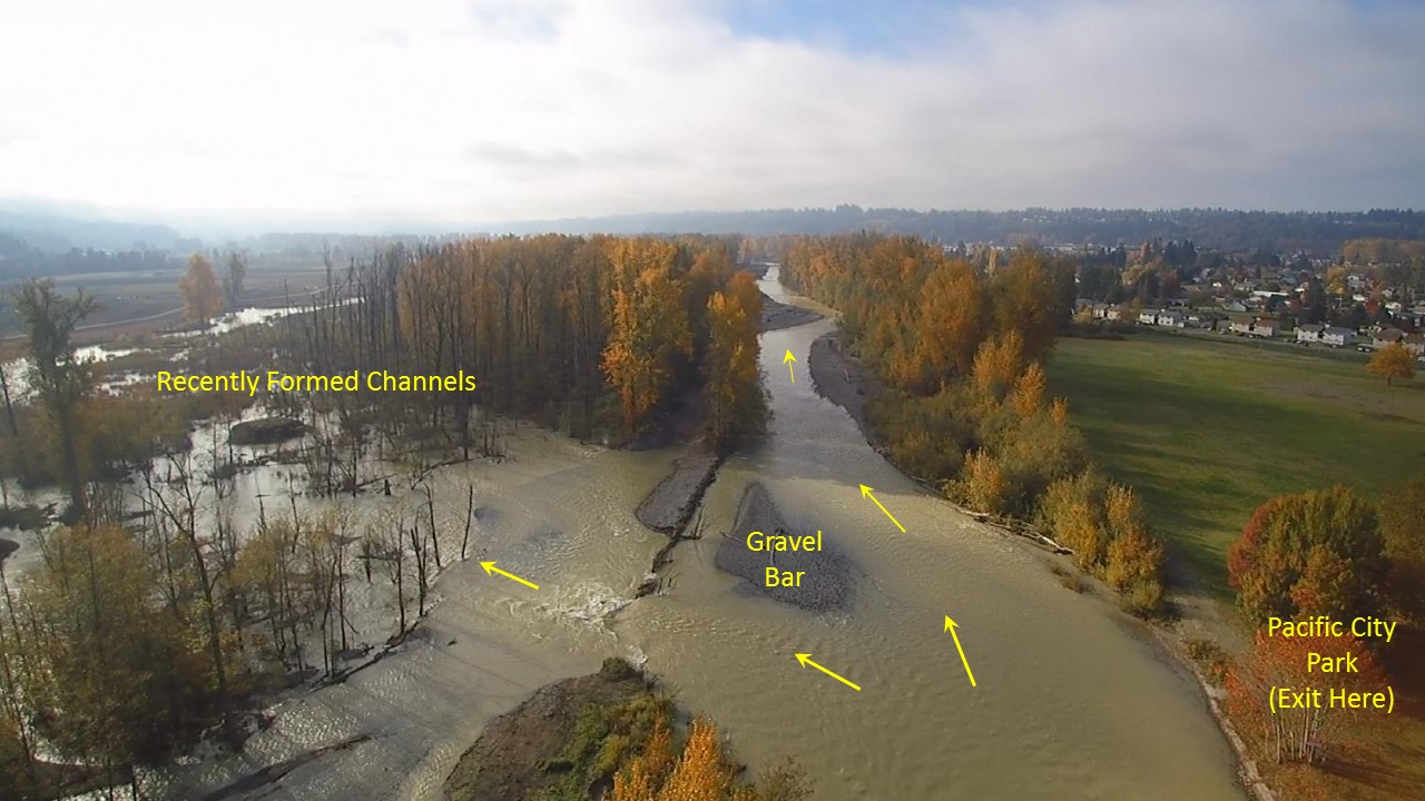
White River below River Mile 6.3
Recreational users on the Lower White River are advised to be on alert for changing river conditions downstream of the A Street Bridge. This segment of the White River has historically experienced shifting gravel bars and relatively high rates of large wood loading due in part to the high sediment load in the White River. In 2017, King County completed construction of the Countyline levee setback project, which removed a portion of the old levee on the left (east) bank across from Pacific City Park and constructed a new levee to the east. A mid-channel gravel bar at river mile (RM) 6.1 (across from Pacific Park) diverts a portion of flow to river left through the location of the old levee and into a series of recently formed channels. The new channel area contains abundant natural wood that may span one or more of the new channels, as well as engineered logjams constructed in the floodplain and along the bank as part of the Countyline project. All floaters and boaters are advised to exit river right at Pacific City Park to avoid entering the recently formed channels.

The above information has been pulled from the King County website. The Auburn Examiner has not independently verified its contents.